DroneSense Announces Plans for a Secure Communications Solution for Public Safety Drone Operations

AUSTIN, Texas, April 11, 2023 (Newswire.com) - DroneSense, the leading software platform for drones in public safety, announces plans to design and manufacture a secure, National Defense Authorization Act (NDAA) compliant, drone-agnostic device that is designed to extend operational and geographic capabilities and provide information security measures for public safety drone operations.
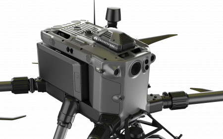
This onboard device will be added to DroneSense's existing portfolio of software, hardware, and professional services designed for public safety drone operations. This solution would operate as an add-on to popular public safety drones, like a backpack computer, and will act as the brain of the drone. It will operate with First Responder traffic prioritization, or FirstNet radio frequency, and 4G/5G data connectivity to remotely command and control aircraft, bypassing the existing radio frequency link used to operate drones from the ground. Additionally, the device provides secure real-time live streaming and end-to-end 256-bit data encryption to maintain security for all public safety information.
"We've seen drone operations bring immediate value to public safety, directly saving lives," said Christopher Eyhorn, CEO of DroneSense. "Ten years ago, only the largest agencies had access to aerial situational awareness with helicopters or crewed aviation. More recently, drones introduced the opportunity for any agency to get aerial intelligence with increased safety and dramatically lower costs for a much wider range of emergency incidents. Our goal is to equip public safety agencies with the best tools possible to help them do their jobs and ensure the safety and data integrity of their missions. This device is the next step in advancing drone technology to increase security and overall greater utilization of drone operations globally."
In addition to improving data security, this solution is beneficial for flights where the drone is flown beyond visual range of the operator, commonly referred to as beyond visual line of sight (BVLOS), by leveraging existing 4G/5G networks over proprietary RF protocols used on ground controllers. Furthermore, it puts additional intelligence onboard the aircraft to enable altitude limits, no-fly zones, and emergency landing sites even if the drone loses its connection. This will be especially valuable in regions with maximum radio frequency power limitations that limit the range of existing drone controllers.
"DroneSense lives by our mission to support and improve outcomes for public safety and first responders," Eyhorn says. "There has recently been a great deal of attention paid to the use of drones in public safety, with some legislators proposing blanket bans on drones manufactured in certain countries due to information security and data sovereignty concerns. We fully support the need to protect American national security and have designed this product to meet those needs and give agencies maximum choice when selecting the best tools to do their jobs. There are many technologies, like cell phones for example, that we utilize every day which are developed in other countries but rely on U.S.-made software to provide robust security for sensitive data. DroneSense onboard will provide a similar solution for drones."
This product is currently in concept and plans are accelerated to enable availability in late 2023. This drone-agnostic solution will be compatible with multiple drone hardware devices, with plans to expand to non-drone platforms, including manned aviation and robotics in the future. For more information, visit discover.dronesense.com/onboard.
About DroneSense
Based in Austin, Texas, DroneSense offers a comprehensive solution that empowers organizations to build, manage, and scale uncrewed aircraft programs. The company's mission-critical software platform enables users to leverage the full capabilities of drones in all operations. Drones powered by the DroneSense platform provide decision-quality data that expands situational awareness and acts as a force multiplier, ultimately leading to more lives saved and safer outcomes in public safety. To learn more about DroneSense, please visit www.dronesense.com.
Source: DroneSense
