SkyWatch Announces Content Store for ArcGIS
SAN DIEGO, July 16, 2024 (Newswire.com) - SkyWatch Space Applications Inc. ("SkyWatch"), a leader in the geospatial data technology industry, announced today, at the Esri User Conference, SkyWatch Content StoreTM for ArcGIS, which provides customers with an integrated solution to discover, purchase and use premium geospatial data natively within the ArcGIS Online platform.
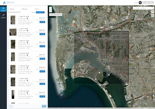
SkyWatch, a member of the Esri Partner Network, has gained a deep understanding of the Esri ecosystem and has worked collaboratively with ArcGIS customers to understand the requirements for accessing and using geospatial content in their workflows. SkyWatch released an add-in for ArcGIS Pro in May 2023, and the launch of Content Store for ArcGIS, a web application built on and deeply integrated with ArcGIS, offers a world-class user experience and unlocks additional functionality for ArcGIS customers, including authentication with ArcGIS credentials, the ability to use existing layers from My Content, My Organization, and Living Atlas to search for content, and seamless publishing of imagery layers for easy sharing and analysis within ArcGIS.
SkyWatch Content Store will initially provide very high-resolution (10-30cm) and high-resolution (50-70cm) archive data from leading providers, including Airbus, Planet, Satellogic, and Urban Sky, with tasking, vector content, and derived data products on the roadmap for later this year.
SkyWatch Content Store for ArcGIS is powered by the SkyWatch platform, which provides a core suite of platform services, including ordering and payments, identity management across SkyWatch applications, policy enforcement, and location services.
“The goal of our partnership with Esri has always been to support their customers by improving access to geospatial content within ArcGIS, and offering recent, high-quality data from the world’s leading providers,” says James Slifierz, CEO at SkyWatch. “Esri is the global leader in geographic information system (GIS) software and location intelligence, and SkyWatch is the world’s leading geospatial data platform. We’re proud to offer a solution to the Esri ecosystem that combines our respective strengths to empower Esri customers with unprecedented access to geospatial content for mapping and analysis.”
“We’re excited about the launch of SkyWatch Content Store for ArcGIS,” says Deane Kensok, ArcGIS Content CTO at Esri. “Leveraging SkyWatch’s domain expertise and data partnerships within ArcGIS unlocks tremendous value for our customers, and sets the stage for continued innovation and collaboration to best serve their needs.”
SkyWatch Content Store for ArcGIS is scheduled for public release in August 2024. To learn more, and to request early access, visit https://skywatch.com/products/map/content-store/.
About Esri
Esri, the global market leader in geographic information system (GIS) software, location intelligence, and mapping, helps customers unlock the full potential of data to improve operational and business results. Founded in 1969 in Redlands, California, USA, Esri software is deployed in hundreds of thousands of organizations globally, including Fortune 500 companies, government agencies, nonprofit institutions, and universities. Esri has regional offices, international distributors, and partners providing local support in over 100 countries on six continents. With its pioneering commitment to geospatial technology and analytics, Esri engineers the most innovative solutions that leverage a geographic approach to solving some of the world’s most complex problems by placing them in the crucial context of location. Visit us at esri.com.
About SkyWatch
SkyWatch is changing the way geospatial data is managed, distributed, and accessed through the SkyWatch platform by partnering with data providers, application developers, and end-user organizations in order to improve our planet through the innovative use of geospatial data.
Source: SkyWatch