Scribble Maps Integrates Earth Observation Data Into Its Platform With SkyWatch BUILD
TORONTO, August 28, 2024 (Newswire.com) - Scribble Maps, a leading online mapping tool known for its user-friendly interface and robust feature set, is thrilled to announce the successful integration of Earth observation data into its platform. This enhancement, powered by SkyWatch’s BUILD application, brings a new dimension of geospatial intelligence to Scribble Maps, enabling users across various industries to access and use up-to-date satellite data directly within their custom maps.
Elevating Mapping Capabilities with Earth Observation Data
Scribble Maps has long been recognized for its versatility, offering users the ability to create, customize, and share maps for a wide range of applications — from urban planning and logistics to environmental management and education. With the integration of Earth observation data, users can now access high-resolution satellite imagery and advanced geospatial data sets, elevating the platform’s capabilities to new heights.
This integration allows users in sectors such as urban planning, real estate, logistics, and environmental management to leverage satellite data for more informed decision-making. For example, urban planners can now overlay satellite imagery on their maps to monitor land use changes, while logistics managers can track the environmental impact of their supply chains with unprecedented accuracy.
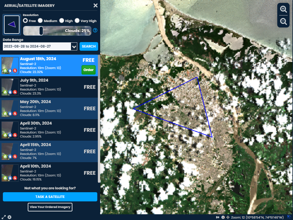
SkyWatch's BUILD Platform: The Power Behind the Integration
SkyWatch's BUILD platform played a crucial role in making this integration seamless, offering a turnkey solution with comprehensive platform services that enable everything from user management to ordering and processing, to payments.
“Bringing easily accessible earth observation imagery and insights into Scribble Maps was always one of our dreams and Skywatch’s BUILD made this dream a reality. Now everyone from novice to experienced can quickly secure recent imagery to conduct analysis without ever needing to leave our platform. This integration truly supports our mission of making mapping accessible to all,” says Jonathan Wagner, CEO of Scribble Maps.
“We are excited to see Scribble Maps leverage the power of our BUILD platform to bring Earth observation data to their users,” says David Proulx, Chief Product Officer at SkyWatch. “This integration exemplifies the flexibility and scalability of our platform, enabling companies like Scribble Maps to enrich their offerings and provide users with cutting-edge geospatial insights. It’s a significant step forward in democratizing access to high-quality satellite data across industries and applications.”
Empowering Industries with Advanced Geospatial Insights
The integration of Earth observation data into Scribble Maps is set to benefit users across multiple verticals, including:
- Oil & Gas: Monitor pipeline integrity, assess environmental risks, and optimize site selection with accurate, up-to-date satellite imagery.
- Urban Planning and Development: Monitor urban sprawl, assess environmental impacts, and visualize growth patterns with real-time satellite data.
- Real Estate: Enhance property assessments by incorporating up-to-date imagery and spatial analysis.
- Logistics and Supply Chain Management: Track environmental factors and optimize routes using the latest geospatial data.
- Environmental Management: Assess environmental changes, track deforestation, and monitor water resources more effectively.
- Government and Public Sector: Support infrastructure projects, disaster management, and public policy with accurate, up-to-date data.
Scribble Maps imagery marketplace offers an innovative, patent-pending feature that allows users to select and purchase satellite imagery with no minimum area warnings. This feature further empowers users across these industries, enabling them to acquire the precise data they need without unnecessary frustration.
With this new capability, Scribble Maps continues to innovate and expand the possibilities for its diverse user base, ensuring they have the tools necessary to succeed in an increasingly data-driven world.
Not only can Scribble Maps users create and use SkyWatch accounts, but existing SkyWatch users can also access data they’ve already purchased within the SkyWatch platform in Scribble Maps, enhancing the usability of data across applications.
About Scribble Maps
Scribble Maps is an intuitive online mapping tool that allows users to create, customize, and share maps with ease. Whether for professional use in industries like urban planning, logistics, and environmental management or for educational and research purposes, Scribble Maps provides a versatile platform that caters to a wide range of mapping needs. Its powerful features include the ability to draw shapes, add markers, import data, and perform complex spatial analyses, making it a preferred choice for both casual and professional users. Learn more at scribblemaps.com.
About SkyWatch
SkyWatch is changing the way geospatial data is managed, distributed, and accessed through the SkyWatch platform and applications. SkyWatch partners with data providers, application developers, and end-users, enabling organizations across various sectors to leverage this data for better decision-making and innovation.
Source: SkyWatch