Jeffrey R. Powlowsky Introduces New Mapping Drone Through Startup

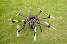
Annapolis, MD, June 19, 2017 (Newswire.com) - Jeff Powlowsky from Annapolis, Maryland, is the brains behind Norma, a lightweight drone with automatic flight, taking off without effort and being able to sustain its flight even in high wind speeds. While a drone is nothing new, Powlowsky's idea is revolutionary because he has targeted online mapping facilities in particular. And it seems that his idea has taken off — just like his drone — since different unmanned aircraft data companies have already expressed an interest in it.
What Powlowsky's startup has done is develop a brand new piece of technology whereby professionals all over the world would be able to map the surface of a geographical area ten times faster than before. Furthermore, his technology guarantees that the drone will not crash, something that continues to be a problem with other models available today. He says: "Norma has some very unique properties, and these ensure that she can do the hardest drone jobs around, guaranteed."
He continues: "Thanks to the technology I have developed, I expect that there will be at least 50 percent savings with regards to time. This means that the companies that buy into the drone can also save a whole lot of money by no longer wasting resources, time, and equipment."
Norma has been designed to cover a square kilometer in just 30 minutes. The ground sampling distance will be just three centimeters. Powlowsky adds: "I am so excited to be able to work with some of the biggest aircraft data companies! This has given me the opportunity to utilize their existing operational expertise, meaning that I can make Norma even better than I had initially expected."
A representative from one of the companies who has expressed an interest in Norma says: "We like Norma because she will make it far more efficient and far safer to collect data from the air. This means that every industry will be able to easily reach for the skies, ensuring that they can analyze real information, making their entire business better at the same time. This really is an exciting project and we're very happy to work together with Jeff Powlowsky."
One other key thing that Jeff has implemented in Norma is that the mapping should be 100% easy. As such, he ensures that only four steps are required to complete a mapping job. The first step is the generation of the flight plan, which indicates the exact project area, guaranteeing its accuracy. Powlowsky adds: "Norma will have all the necessary equipment to ensure a flight plan will be followed with 100 percent accuracy. Obviously, she will have highly accurate GPS technology and more."
The second step of operation is to set the drone off. As soon as Norma is in the air, which only requires a single push of a button, she will then follow the flight plan and start to collect data from the specified area. The company representative adds: "One of the things we asked Jeff to do was ensure that setting the drone off didn't require a degree in mechanical engineering. This is something we want our interns to be able to do, in other words. And again, he has come through for us."
The third step is to wait for Norma at the spot that was designated for landing when entering the flight data. The data that she has captured will then automatically be organized properly and will be processed with ease. Powlowsky adds: "This is a particular little bit of genius, if I say so myself. I have worked with software developers and app developers to make sure that the data Norma collects can be processed by any kind of image processing software. This means that companies don't need to install new software and retrain either."
The final step is to use the software that comes with Norma, which enables users to create a detailed analysis of the data that has been collected. How this will be used will depend on the company that employs her. However, it is likely that it will be used to create maps for driving, GPS systems, driverless cars, and more.
Norma will have a range of up to 60 kilometers. She can function in a weather limit of up to six on the Beaufort scale and she will be completely rain proof. Her ground sample distance (GSD) will be up to 1.5 centimeters, closer than any other modern drone can achieve. As a typical take-off and landing area, she should have a space of two meters by two meters. Finally, with a GSD of just three centimeters, Norma can map a square kilometer in just half an hour.
Source: Jeffrey R. Powlowsky