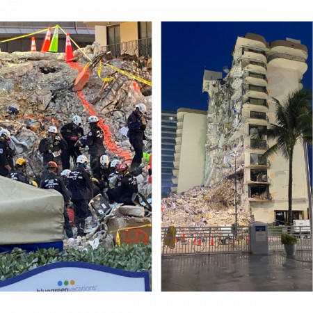
DroneSense Assisted Emergency Teams at Surfside Building Collapse

AUSTIN, Texas, December 1, 2021 (Newswire.com) - DroneSense responded to a Florida emergency service's need for assistance following the Surfside building collapse and demonstrated its unmatched ability to provide collaborative unmanned aircraft software and logistical support in emergency and public safety efforts. An experienced DroneSense specialist was embedded with one of the emergency task force teams and assigned responsibilities for logistics and operations, contributing to safety, efficiency and situational awareness throughout the mission.
The tragic collapse of the Champlain Towers South condominium in Miami's Surfside suburb on June 24 required a large-scale effort by Miami-area first responders to search for survivors and secure the area. Emergency services leveraged the assistance of Austin, Texas-based DroneSense, which dispatched personnel to the Surfside site within two hours of the request.
"We were able to respond immediately and provide coordinated technical and logistical support because we are designed for public safety and we've got teammates with experience operating in these challenging environments," said DroneSense Co-Founder and CEO Chris Eyhorn.
The City of Miami Fire Department was one of the agencies that responded to the disaster site, with a state emergency response triggered two days after. Subsequent teams contributed additional rescue, medical and structural engineering capabilities and the response later widened to include federal Urban Search and Rescue teams. Several agencies used unmanned aircraft to augment their operations and the DroneSense team collaborated with them closely to enhance overall situational awareness utilizing the DroneSense platform. Synthesizing and managing information is crucial in large and complex operations like Surfside, which involve multiple agencies gathering large quantities of time-sensitive safety-related data.
"It was great to see organizations and individuals helping when Miami needed it, including providing unmanned aircraft," said Eyhorn. "DroneSense stood out by not simply flying drones but using our platform to coordinate operations and bring crucial insights to operators and executives instantly. This enabled the command center to receive the right information at the right time to produce better decisions."
The DroneSense platform is purpose-built for public safety and is used by fire, police, and emergency medical professionals around the country. Its cross-platform video support enables any drone or camera -- including fixed cameras and phones -- to livestream video to operators and decision-makers located anywhere. DroneSense's spatial awareness tools within the platform enabled teams to collaboratively identify regions of interest and assign responsibilities for personnel on scene, facilitating search and rescue and recovery. DroneSense was also able to account for all the pilots, flights and assets used during the operation using their end-to-end management web app, giving safety officials a full system of record and up-to-the-minute accountability for this critical operation.
The DroneSense platform was used at Surfside site to:
- Create 2D/3D maps and document the site. The site was flown every two hours during daylight to monitor and track work progress.
- Aid with interior search and rescue
- Examine forensic architecture
- Assess site safety and security
- Assist with PIO/media relations
- Monitor work on the 'pile' and in 'pit' through mobile streaming and tracking
- Livestream recovery efforts to command
About DroneSense
Based in Austin, Texas, DroneSense offers a comprehensive solution that empowers organizations to build, manage, and scale unmanned aircraft programs. The company's mission-critical software platform enables users to leverage the full capabilities of drones in all operations. Drones powered by the DroneSense platform provide decision-quality data that expands situational awareness and acts as a force multiplier, ultimately leading to more lives saved and safer outcomes in public safety. To learn more about DroneSense, please visit www.dronesense.com.
DroneSense is a trademark of DroneSense, Inc., Facebook is a trademark of Facebook, Inc., and Twitter is a trademark of Twitter, Inc.
Media Contact:
Bianca Facey
(203)577-7588 (Direct)
bianca@newswire.com
www.Newswire.com
Source: DroneSense
